CNES land cover classification visualisation script
//VERSION=3

// This scripts visualise land cover over Metropolitan France

// Set up input and output settings
function setup() {
    return {
      input: [{
        bands: [
          "OCS"
        ]
      }],
      output: {
        bands: 4
      }
    }
  }

//EvaluatePixel function - return corresponding color based on CNES Land Cover nomenclature and colouring scheme
function evaluatePixel(samples) {
    const val = samples.OCS;
    if (val == 1) {
        return [1, 0, 1, 1];
    } else if (val == 2) {
        return [1, 85/255, 1, 1];
    } else if (val == 3) {
        return [1, 170/255, 1, 1];
    } else if (val == 4) {
        return [0, 1, 1, 1];
    } else if (val == 5) {
        return [1, 1, 0, 1];
    } else if (val == 6) {
        return [208/255, 1, 0, 1];
    } else if (val == 7) {
        return [161/255, 214/255, 0, 1];
    } else if (val == 8) {
        return [1, 171/255, 68/255, 1];
    } else if (val == 9) {
        return [214/255, 214/255, 0, 1];
    } else if (val == 10) {
        return [1, 85/255, 0, 1];
    } else if (val == 11) {
        return [197/255, 1, 1, 1];
    } else if (val == 12) {
        return [170/255, 170/255, 97/255, 1];
    } else if (val == 13) {
        return [170/255, 170/255, 0, 1, 1];
    } else if (val == 14) {
        return [170/255, 170/255, 1, 1];
    } else if (val == 15) {
        return [85/255, 0, 0, 1];
    } else if (val == 16) {
        return [0, 156/255, 0, 1];
    } else if (val == 17) {
        return [0, 50/255, 0, 1];
    } else if (val == 18) {
        return [170/255, 250/255, 0, 1];
    } else if (val == 19) {
        return [85/255, 170/255, 127/255, 1];
    } else if (val == 20) {
        return [1, 0, 0, 1];
    } else if (val == 21) {
        return [1, 184/255, 2/255, 1];
    } else if (val == 22) {
        return [190/255, 190/255, 190/255, 1];
    } else if (val == 23) {
        return [0, 0, 1, 1];
    } else if (val == 0 || val == 255) {
        return [1, 1, 1, 0];
    } else {
        return [0, 0, 0, 1];
    }
}General description of the script
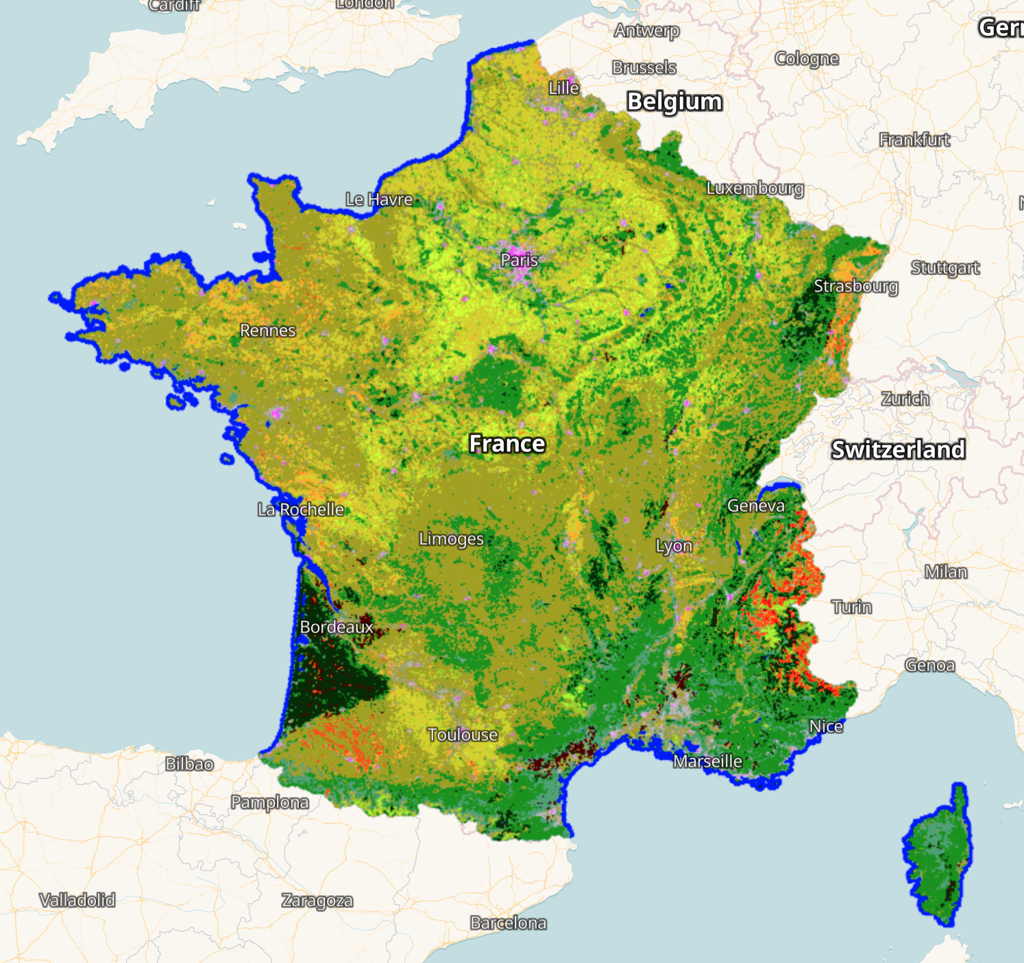
The script visualises land cover over Metropolitan France using a 23-categories nomenclature.
Table 1: Color legend for CNES land cover classification map
| Value | Color | Color Code | Label |
|---|---|---|---|
| 1 | #ff00ff | Dense built-up area | |
| 2 | #ff55ff | Diffuse built-up area | |
| 3 | #ffaaff | Industrial and commercial areas | |
| 4 | #00ffff | Roads | |
| 5 | #ffff00 | Oilseeds (Rapeseed) | |
| 6 | #d0ff00 | Straw cereals (Wheat, Triticale, Barley) | |
| 7 | #a1d600 | Protein crops (Beans / Peas) | |
| 8 | #ffab44 | Soy | |
| 9 | #d6d600 | Sunflower | |
| 10 | #ff5500 | Corn | |
| 11 | #c5ffff | Rice | |
| 12 | #aaaa61 | Tubers/roots | |
| 13 | #aaaa00 | Grasslands | |
| 14 | #aaaaff | Orchards and fruit growing | |
| 15 | #550000 | Vineyards | |
| 16 | #009c00 | Hardwood forest | |
| 17 | #003200 | Softwood forest | |
| 18 | #aaff00 | Natural grasslands and pastures | |
| 19 | #55aa7f | Woody moorlands | |
| 20 | #ff0000 | Natural mineral surfaces | |
| 21 | #ffb802 | Beaches and dunes | |
| 22 | #bebebe | Glaciers and eternal snows | |
| 23 | #0000ff | Water |
Description of representative images
The overview of CNES Land Cover 2020 for France visualised in EO Browser
CNES Land Cover 2020 around Lyon visualised in EO Browser
