SAVI (Soil Adjusted Vegetation Index)
// Soil Adjusted Vegetation Index  (abbrv. SAVI)
// General formula: (800nm - 670nm) / (800nm + 670nm + L) * (1 + L)
// URL https://www.indexdatabase.de/db/si-single.php?sensor_id=96&rsindex_id=87
function setup() {
   return {
      input: ["B04", "B08", "dataMask"],
      output: { bands: 4 }
   };
}

let L = 0.428; // L = soil brightness correction factor could range from (0 -1)

const ramp = [
   [-0.5, 0x0c0c0c],
   [-0.2, 0xbfbfbf],
   [-0.1, 0xdbdbdb],
   [0, 0xeaeaea],
   [0.025, 0xfff9cc],
   [0.05, 0xede8b5],
   [0.075, 0xddd89b],
   [0.1, 0xccc682],
   [0.125, 0xbcb76b],
   [0.15, 0xafc160],
   [0.175, 0xa3cc59],
   [0.2, 0x91bf51],
   [0.25, 0x7fb247],
   [0.3, 0x70a33f],
   [0.35, 0x609635],
   [0.4, 0x4f892d],
   [0.45, 0x3f7c23],
   [0.5, 0x306d1c],
   [0.55, 0x216011],
   [0.6, 0x0f540a],
   [1, 0x004400],
];

const visualizer = new ColorRampVisualizer(ramp);

function evaluatePixel(samples) {
   const index = (samples.B08 - samples.B04) / (samples.B08 + samples.B04 + L) * (1.0 + L);
   let imgVals = visualizer.process(index);
   return imgVals.concat(samples.dataMask)
}
// Soil Adjusted Vegetation Index (abbrv. SAVI)
// General formula: (800nm - 670nm) / (800nm + 670nm + L) * (1 + L)
// URL https://www.indexdatabase.de/db/si-single.php?sensor_id=96&rsindex_id=87
function setup() {
return {
input: ["B03", "B04", "B08", "dataMask"],
output: [
{ id: "default", bands: 4 },
{ id: "index", bands: 1, sampleType: "FLOAT32" },
{ id: "eobrowserStats", bands: 2, sampleType: 'FLOAT32' },
{ id: "dataMask", bands: 1 }
]
};
}
let L = 0.428; // L = soil brightness correction factor could range from (0 -1)
const ramp = [
[-0.5, 0x0c0c0c],
[-0.2, 0xbfbfbf],
[-0.1, 0xdbdbdb],
[0, 0xeaeaea],
[0.025, 0xfff9cc],
[0.05, 0xede8b5],
[0.075, 0xddd89b],
[0.1, 0xccc682],
[0.125, 0xbcb76b],
[0.15, 0xafc160],
[0.175, 0xa3cc59],
[0.2, 0x91bf51],
[0.25, 0x7fb247],
[0.3, 0x70a33f],
[0.35, 0x609635],
[0.4, 0x4f892d],
[0.45, 0x3f7c23],
[0.5, 0x306d1c],
[0.55, 0x216011],
[0.6, 0x0f540a],
[1, 0x004400],
];
const visualizer = new ColorRampVisualizer(ramp);
function evaluatePixel(samples) {
const val = (samples.B08 - samples.B04) / (samples.B08 + samples.B04 + L) * (1.0 + L);
// The library for tiffs works well only if there is only one channel returned.
// So we encode the "no data" as NaN here and ignore NaNs on frontend.
const indexVal = samples.dataMask === 1 ? val : NaN;
const imgVals = visualizer.process(val);
return {
default: imgVals.concat(samples.dataMask),
index: [indexVal],
eobrowserStats: [val, isCloud(samples) ? 1 : 0],
dataMask: [samples.dataMask]
};
}
function isCloud(samples) {
const NGDR = index(samples.B03, samples.B04);
const bRatio = (samples.B03 - 0.175) / (0.39 - 0.175);
return bRatio > 1 || (bRatio > 0 && NGDR > 0);
}// Soil Adjusted Vegetation Index (abbrv. SAVI)
// General formula: (800nm - 670nm) / (800nm + 670nm + L) * (1 + L)
// URL https://www.indexdatabase.de/db/si-single.php?sensor_id=96&rsindex_id=87
function setup() {
return {
input: ["B04", "B08"],
output: {
bands: 1,
sampleType: "FLOAT32"
}
};
}
let L = 0.428; // L = soil brightness correction factor could range from (0 -1)
function evaluatePixel(samples) {
const index = (samples.B08 - samples.B04) / (samples.B08 + samples.B04 + L) * (1.0 + L);
return [index]
}Evaluate and Visualize
General description of the script
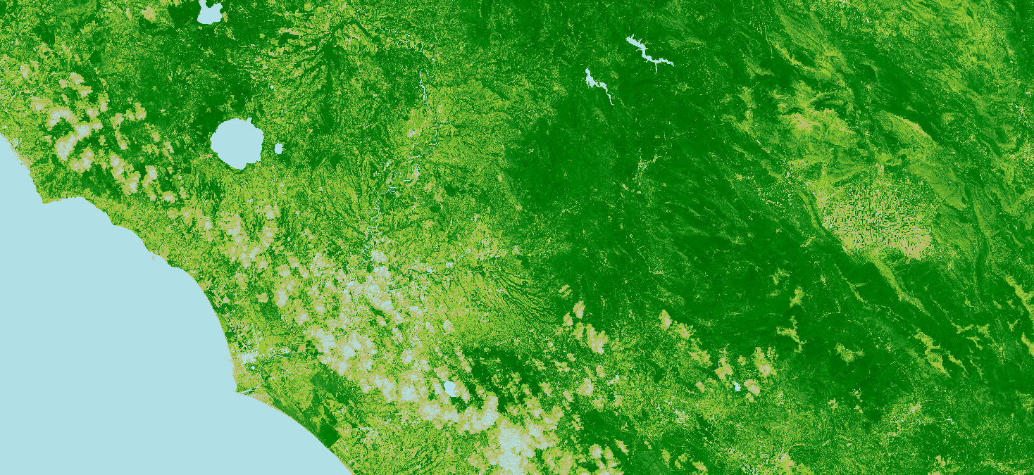
For Sentinel-2, the index looks like this:
\[SAVI = \frac{B8-B4}{B8+B4+L} \cdot (1+L)\]where $L$ is the soil brightness correction factor and could range from (0 -1).
Empirically derived NDVI products have been shown to be unstable, varying with soil colour, soil moisture, and saturation effects from high density vegetation. In an attempt to improve NDVI, Huete [1] developed a vegetation index that accounted for the differential red and near-infrared extinction through the vegetation canopy. The index is a transformation technique that minimizes soil brightness influences from spectral vegetation indices involving red and near-infrared (NIR) wavelengths.
Description of representative images
SAVI visualized image, Italy. Acquired on 25.05.2020, processed by Sentinel Hub.
References
Wikipedia article on Soil adjusted vegetation index
Contributors:
Dorothy Rono